Soil Innovation
Soil Innovation
The Coorong Tatiara Local Action Plan is currently delivering a suite of projects in the area of Sandy Soils and Soil Innovation.
We have developed the Project Concept 'Livestock Production on Sandy Soils - Lets make the Bucket Bigger', and are actively working with our partners to realise the ideas outlined in this document, which would deliver both agricultural production and land management benefits. Please click the link to learn more.
Funding Partners
These projects are supported by the Australian Government’s Region Land Partnerships initiative of the National Landcare Program, Landscapes SA Limestone Coast, Landscapes SA Murraylands and Riverland, and Meat and Livestock Australia.
For more information about our recent soil related farm walks and events please click here.
Project Background
Improving soil health across our landscape will result in a number of benefits including;
- Increased livestock feed production
- Improving the ability to capture rainfall where it falls
- Improved resilience to adverse conditions
- Reduced wind erosion
- Reduced recharge to groundwater, delivering dryland salinity benefits
- Understanding & improvements in; groundcover, soil pH, carbon, structure, water holding capacity
Identifying & treating soil constraints to maximise plant access to all of the available moisture & nutrients in the soil profile is the key to unlocking these benefits.

Brian Hughes of PIRSA Rural Solutions pointing out features of the soil pit at the Meningie East Healthy Soils Farm Walk August 2020
Soil constraints we are interested in exploring include, but are not limited to

We are interested in transferring innovations to sandy grazing country to test soil measurements and amelioration techniques including, but not limited to
Please find below links to interesting resources on a range of topics around;
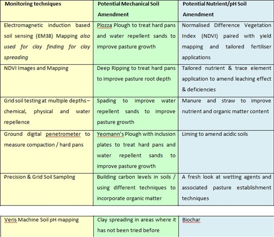
Soil measurement and mapping techniques
Soil constraints to production
Soil amendments; mechanical, chemical & biological
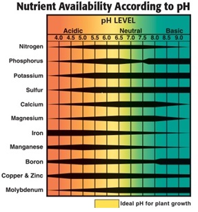
Soil pH, acidity, liming and the Veris Machine
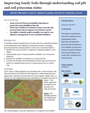
The Improving Sandy Soils through understanding soil pH and soil potassium status report covers use of a range of soil testing technologies on a sandy – sandy loam, continuously cropped paddock in the Yumali – Ki Ki area;
- Use Veris Machine Mapping technology was used to identify spatial variation in pH,
- Use of grid sampling to explore mapped spatial variation in Potassium, Phosphorus, and Sulphur.
Please click on the link below to to access the full report
Improving Sandy Soils through understanding soil pH and soil potassium status report
Other pH and liming resources
The Dollars and Sence of Liming : The Stanton's story, click on the hyperlink below for more:
Kangaroo Island Liming Fact Sheet and Case Study (1072 kb)
Kym and Katie IÁnson's philosophy is to grow healthy profitable crops but to do this they need to overcome soil constraints an match inputs to potential production. Includes information on the Veris Machine used to map the pH of soils.
To read more clink on the hyperlink below:
Footage of Veris Machine operationVideo credit: Paul Ruchs - Landmark
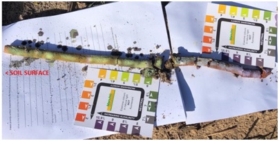
Soil pH down the soil profile - Coorong District
EM38 Mapping
Upper South East Sustainable Soils - EM38 Mapping for Clay Finding
The Upper South East Sustainable Soils – EM38 Mapping for Clay Finding Report covers use of EM38 soil mapping technology to spatially locate clay and other soil properties below the soil surface to aid in soil management decision making.
- EM38 technology works better in some regions than others to locate clay. The spatial data generated can then be utilised to reduce costs when looking to ameliorate soils,
- In situations where clay isn’t detected, the EM38 still relates strongly to production, and has the potential to be utilised for other soil management strategies.
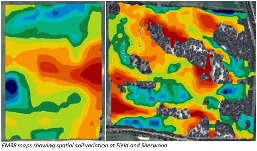
EM38 maps showing spatial soil variation at Field and Sherwood
Three sites were EM38 mapped as case studies in this report. Recommendations, products, and findings drawn from the EM38 mapping data varied between the sites and include;
- Identification and differentiation of sites within paddocks that were suitable for clay spreading, delving, or ripping. This differentiation allows cost effective application of mechanical soil amelioration techniques to be applied in the right location.
- Effective location of clay pits for clay spreading.
- Provision of a GIS based EM38 paddock map to the machinery operator can be used to provide depth to clay information to inform operator depth control in a delving or ripping situation to maximise contractor, time and horsepower efficiency.
- On deep sandy soil sites, identification of rock in the paddock to be avoided when ripping.
- Relationships established between EM38 results and NDVI pre grazing suggest soil properties are driving feed production.
Further information about use of EM38 technology and soil moisture probes can be found by clicking on the 'EM38, Soil Moisture Probes, and Soil Variability' fact sheet below under Soil Moisture Probes.
Soil Moisture Probes
Further information about use of EM38 technology and soil moisture probes can be found by clicking on the fact sheet below.
EM38, Soil Moisture Probes, and Soil Variability
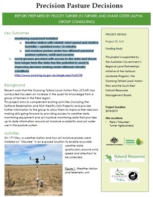
Precision Pasture Decisions Project – Field, South Australia
The Precision Pasture Decisions Project was delivered in 2019 in the Field area east of Meningie.
The project included installation of monitoring equipment including;
- Field location weather station with rainfall, wind speed and relative humidity – updated every 15 minutes.
- Soil moisture probes under two different perennial pasture systems; Veldt Grass and Lucerne.
Local growers shown how to access weather and moisture probe data, and shown this data has the potential to assist in improving decision making under different climatic conditions. This was provided 1:1 and at a Pasture Farm Walk held on the 25th of June with 18 people in attendance.
This project report and more information about accessing and interpreting the information produced, can be accessed by clicking on the document link below.
Precision Pasture Decisions Project Report
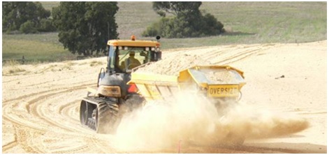
Ripping and Spading articles
Clay and hay increases yields on South East sands - GRDC Sandy Soils Project (429 kb)
Stock Journal article 'Ripping results for SA sandy soil sites'
Stock Journal article 'Thinking before ripping into sandy soils'
GRDC's Deep Ripping Fact Sheet 'Deep Ripping Not Appropriate For All Soil Types'
Stock Journal article 'Big win with new spader'
Clay spreading and stabilisation of sands
Clay spreading and stabilisation of sands link to Coorong Tatiara Local Action Plan web page
On farm lime sources
Grain growers can save considerable dollars by making use of on-farm agricultural lime, rather than freighting lime from afar.
Download the online Factsheet "Locating and Assessing On-Farm Lime Sources" by using the link below.
Locating and assessing on-farm lime sources (4742 kb)
