Bushfire Recovery

Photo credit: Caroline Johnson
The Yumali Bushfire started on the afternoon of 19 November 2020, and burned more than 4,876 hectares with a perimeter of 82 kilometres. This fires impacted 14 farm businesses, livestock, crops, hay, numerous sheds, vehicles, and hundreds of kilometres of fencing. This is a significant blow to many members of our local community.
Several fires impacted the Coorong District Council area in the fornight leading up to Christmas in December 2019. The Carcuma Fire burnt an area of 6938.3 hectares impacting private land, Carcuma Conservation Park, and eight Heritage Agreements. The Bunbury Bushfire Recovery area covers an area of 7128.5 hectares. The Coonalpyn Fire burnt an area from the eastern edge of the township and then burnt in a north easterly direction crossing Tauragat Well Road.
The Sherwood Bushfire on Saturday the 6th of January 2018 blacked out 12,000ha of farmland during extreme temperatures and strong winds. Six houses, 78 head of cattle and around 2,000 sheep were lost in the blaze.
The nature of these fire events, which were extremely fast moving, meant that members from the farming community and local CFS units were integral in helping to prevent the impacts of the fires from spreading further.
![]()

From left: Mayor Paul Simmons – Coorong District Council, Josh Hancock of Hancock Haulage, and Netherton Farmer Lester Cattle receiving donated hay from Eyre Peninsula
Please click here to access further information in regard to the lessons learnt from the Sherwood Bushfire
The following links and information are provided to assist those who have been impacted by fire events
Coorong District Council’s Mayor Cr. Paul Simmons was part of the fire-fighting efforts and witnessed the actions of landowners and neighbours first-hand.
“I am impressed and grateful to the community of Yumali and Netherton for dealing with this high-risk situation by lending their support in many ways – whether by fighting the fire either with farm units or as part of local CFS brigades, checking on and helping neighbours to evacuate, shifting animals, or giving support to those at the fire front,” says Mayor Cr. Paul Simmons.
“It is events like this where you truly see our communities come together in support of one another.
“While the community of Netherton and Yumali may be small, this fire event has had a devastating impact; one that will be felt by our residents for years to come.”
Media Release - Mayor thankful for efforts of Yumali-Netherton fire volunteers and community
PIRSA's Family and Business (FaB) Support Program is a service to help farmers, farming families and regional businesses during difficult situations like drought, bushfire and other adverse events. This program provides a free, informal, confidential, independent and understanding approach available for individuals, families or businesses in South Australia.
If you’re feeling overwhelmed and don’t know where to start, contact FaBS for support.
PIRSA have appointed Robyn Cain to assist the Yumali-Netherton Community during the fire recovery phase.
Robyn’s contact details are M 0411633085 W FaB web page please click here E robyncain16@gmail.com
Robyn’s recent experiences include supporting drought impacted businesses and communities, hail storm recovery, & also working on the Kangaroo Island Fires. FaBs work closely with service providers and can help connect you to services, including:
- financial counselling
- local health networks
- emotional wellbeing and counselling services
- government and non-government assistance
- community organisations and donations.
Rural Business Support (RBS) is a leading not-for-profit provider of agribusiness services and independent support for farmers and rural-related business owners. RBS offer a range of proactive programs and services that can help to equip farmers and rural-related business owners with financial literacy skills and strategic awareness to make timely decisions and build long term business resilience.


RBS also delivers a Small Business Financial Counselling program, an extension of the RFCS model of support to eligible small business owners impacted by drought, bushfire or the COVID-19 pandemic.
Responding to adverse events such as fire, drought and flood is another key part of what we do and who RBS are. With staff who live and work in the affected areas, we offer experienced and empathic support for those that have been affected by such events, helping eligible rural business owners to work through the decisions and actions needed to recover and to be better prepared for similar challenges in the future.
Our local Rural Financial Counsellor is Lynton Keen who is based in Murray Bridge
E referrals@ruralbusinesssuppoirt.org.au T 1800 836 211 F (08) 8364 2574 M 0448 092 294
More information about Rural Business Support can be found here W www.ruralbusinesssupport.org.au
Rural Business Support Frequently Asked Questions Fact Sheet: click here
The ifarmwell website has been designed by Australian farmers to help other Australian farmers cope effectively with life’s challenges and get the most out of every day. It does this by sharing practical ways of coping with difficult circumstances, thoughts and feelings (especially worries about things you can’t control) and helping you to work out where it is most useful for you to put your attention and energy.
You can do this from the privacy of your home, tractor or shed. The site will even send you text message reminders to keep you focused, & it’s free! Visit www.ifarmwell.com.au to find out more.

Managing light sandy soils post bushfire can be particularly challenging where all groundcover has been lost. Particularly where there is a long wait until the break of the season.
Brian Hughes - Principal Soils Consultant with PIRSA Rural Solutions has developed the Fact Sheet 'Soil erosion management control options For primary producers affected by the Yumali bushfire' in direct response to soil management concerns post Yumali Fire. Please click here to access this Fact Sheet that provides post fire management recommendations for each soil type in the Yumali Netherton Bushfire area.

A case study titled ‘Post Fire management in broad acre farming’ was developed after the Lameroo Fire in late 2015 where delving and spreading pig manure were used to manage drift of sandy soils.
Post fire management in broad acre farming - Lameroo Case Study


Piggery manure applied at 5-6 t/ha vs 0 t/ha Delved subsoil clay acting to catch drifting sand in the furrows
A PIRSA fact sheet titled ‘Emergency measures to curb wind erosion’ was developed after the Pinery fire to advise on emergency erosion control methods after fire. This fact sheet has more of an application on loam and clay soils, but discusses management across the full range of soil types.
Emergency measures to curb wind erosion Fact Sheet
At the Yumali - Netherton Fire Community Meeting on Tuesday, the 1st December Simon Nott of Coorong Platinum Ag gave the following presentation on Fire Recovery Soil Erosion Control. Please click on the link below to access this presentation.

RESEEDING POST FIRE
Click here to see the Cay family’s experience with sowing a cover crop after the Pinery Fire.
This GRDC web page contains information about post fire management of soils and the use of cover crops along with cultivation, clay spreading and delving, best crop types, allowing summer weeds in some cases to act as a cover crop.
Please find here a fact sheet on Sandy Soil constraints in south east South Australia - a guide to their diagnosis & treatment produced by the MacKillop Farm Management Group.
Please find at this link a fact sheet on Soil Testing and Management Advice for Eroded Paddocks produced by Mallee Sustainable Farming and the Murraylands and Riverland Landscape Board.
Managing Livestock
A Stock Containment Information Session was held on Friday, 18th December 2020, visiting a local stock containment area and learning more about Stock Containment and Management with Daniel Schuppan - Animal Production Specialist with Nutrien Ag Solutions. This day was supported by PIRSA and Coorong District Council.

To access Daniel Schuppan's presentation full of useful information please click here

Please click on the links below in regard to breeding ewes and pregnancy toxaemia;
- Managing breeding ewes in containment areas
- Pregnancy toxaemia in breeding ewes
The Murraylands and Riverland Landscape Board have a comprehensive web page that includes information about stock containment and feed budgeting.
- Sheep Connect SA have produced a range of short videos for post fire management which are available on the Sheep Connect SA You Tube Channel. See titles and hyperlinks below.
- Sheep Connect SA videos of producers sharing their experiences of fire recovery, what they did, what they would do the same, and what they would do differently.
- Bushfire Recovery – Charlie Crozier - Sherwood
- Bushfire Recovery - Troy and Nette Fischer – Mid North
- Bushfire Recovery – Glen Tilley – Tarlee
- Information from Barossa Improved Grazing Group (BIGG) on fire recovery after the Eden Valley Fire:
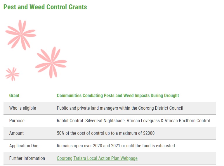
Support has been provided to land managers impacted by the Carcuma and Bunbury Bushfires in December 2019 with remnant vegetation projection, revegetation, and habitat enhancement through the WIRES - Landcare Wildlife Relief and Recovery Grants 2020.
The Department for Environment and Water provides information on Clearing and Fire Recovery which can be accessed here.
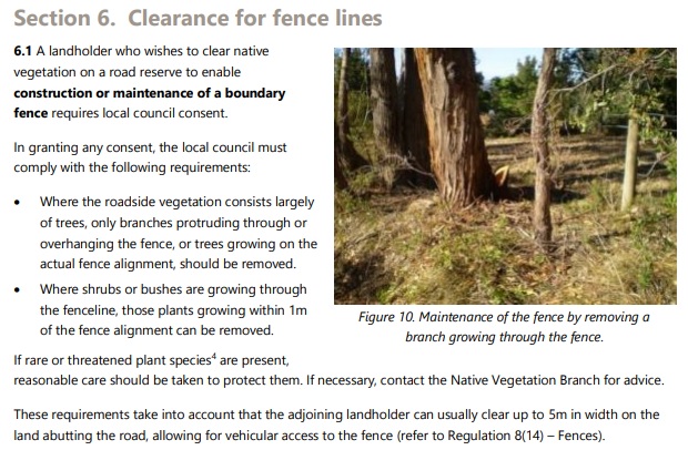
Key information includes clearing fence lines, tracks and dangerous trees.

Detailed information about roadside vegetation management and regulations can be found in the Guidelines for the Management of Roadside Native Vegetation and Regrowth Vegetation Under Native Vegetation Regulation 11(23) which includes amendments made in September 2020. The document can be found here.
The Guidelines include a Section on clearance of fence lines on road reserves on page 24.

If there are Heritage Agreements burnt there may be support for re-fencing through a Departmental insurance claim.
The Financial Support to Replace Burnt Heritage Agreement Fences Fact Sheet (Native Vegetation Council) contains further information.
In this instance please contact Zita Fewster for further information.
Zita Fewster - Significant Environmental Benefit Project Officer
Native Vegetation Branch - Department for Environment and Water
E zita.fewster@sa.gov.au M 0427 976 904
The four fact sheets below contain information around managing native vegetation post bushfire, and around fencelines.
Bushfire Recovery and Biodiversity Fact Sheet
Native Trees in Burnt Areas Fact Sheet
Native Vegetation clearance along Fencelines Frequently Asked Questions
As with other recent bushfires the main funding for recovery is via insurance. The experiences of fellow primary producers recently in the fire recovery phase has given rise to the recommendation that policy guidelines be thoroughly investigated.
Insurance comes in all different shapes and sizes and it can be difficult to know exactly what might be included in your insurance cover.
Here are some tips to consider to maximise your claim;
- Don’t close your claim too quickly, you might think of additional elements in a few months time
- Make sure you ask ‘What does the 'make good' clause cover?’ it could be more than you realise
- Check what is covered under your livestock or cropping cover – some covers include pasture or soil remediation works
- Talk to your neighbours about what they are covered for, it might jog your memory to ask if that is covered under your policy as well
The Insurance Council of Australia 1800 734 621 is available to assist you if you are not happy with the service provided by your policy and to answer specific questions.
At the Yumali - Netherton Fire Community Meeting on Tuesday 1st December 2020, Matt Howell of Coorong Platinum Ag gave the following presentation on Managing Insurance Post Fire. Please click on the link below to access this well received presentation.
Coorong Platinum Ag Property Insurance QA Presentation - Matt Howell


Click here to visit the project web page

Click here to visit the project web page:
Guidelines are currently being finalised. They will be promoted once released.
A Hydraulic Wire Spinner has been loaned to the Yumali - Netherton Bushfire Recovery Area by the Mid North Ag Bureaus.
The wire spinner is attached to hay forks and can be used to roll up old fence lines. The wire spinner works more effectively on cyclone and rabbit netting fences rather than plain wire. Limestone Coast Landscape Board Officer dropped the wire spinner into the Stock Containment Information Session and provided some information to the group assembled.

Please click here to see a short movie below to seek a hydraulic wire spinner in operation
The Pickering Family have the hydraulic wire spinner currently on their property.
Those of you who wish to make use of this spinner please work together to move it around your local area to optimise its use.
General Information and Support Tracey Strugnell Community Engagement and Grants Officer Coorong and Tatiara District Council E: tstrugnell@coorong.sa.gov.au M: 0427 750050 | General Information and Support Tarsha McGregor Recovery Facilitator PIRSA E: tarsha.mcgregor@sa.gov.au M: 0428 105396 | Country Fire Service Yvette Rathjen Regional Community Engagement Officer E: yvette.rathjen@@sa.gov.au M: 85 326 800 | |
Business Support Lynton Keen Rural Financial Counsellor Rural Business Support E referrals@ruralbusinesssuppoirt.org.au T 1800 836 211 M 0448 092 294 | Health and Wellbeing Support Robyn Cain Farm and Business Support - FaB PIRSA M: 0411 287 261 | Buy A Bale - Rural Aid Register for support with financial help, fodder supplies, domestic water, counselling services and more dependent on eligibility. Click here for further information and to register https://www.ruralaid.org.au/buyabale/ | |
Soils and Land Management Brian Hughes Principal Land Management Consultant PIRSA E: brian.hughes@sa.gov.au M: 0429 691468 | Livestock and Animal Production Daniel Shupann Animal Production Specialist Nutrien Ag Solutions E:daniel.shupann@nutrien.com.au M: 0477 315 931 | ||
Livestock and Animal Production Jeremy Rogers Animal Health PIRSA P: 87 629100 | Soils and Land Management James Hall Sustainable Primary Production Team Leader Limestone Coast Landscapes Board E: James.Hall2@sa.gov.au M: 0448 472168 | ||
-Pest and Weed Management Steve Baltussen Riverlands and Murraylands Landscapes Board M: 0427 808205 | Pest and Weed Management Kym Haebich Limestone Coast Landscapes Board P: 8735 1177 M: 0408 811 392 | - Technical support and advice on declared Plant and Pest (rabbit) control to affected landowners, with supply of baitlayers, and ripper. - Roadside inspections in fire affected areas now and in March - Work with Coorong District Council to conduct targeted pest control works | |
Please click here for the latest fact sheet information on African Lovegrass Control

Discussion at the Stock Containment Information Session on 18th December 2020 included;
- the need for tools to assist with measuring fencelines for insurance purposes
- and planning new fenceline layout post fire
AERIAL PHOTOS
The Murraylands & Riverland Landscape Board have kindly offered to print and laminate aerial photos of properties to assist with post fire property and fence line planning.
If this is of interest please provide your property location details (including Hundred, Section, Lot numbers etc.) to tstrugnell@coorong.sa.gov.au.
Please note these will not be produced until after 18th January 2021.
ONLINE MEASUREMENT AND PLANNING TOOLS - all free of cost
South Australian Property and Planning Atlas (SAPPA)
The South Australian Property and Planning Atlas (formerly known as the Property Location Browser) is a free map-based application. Visit the website here: sappa.plan.sa.gov.au
Daft Logic aerial photo based simple distance and aerial measurement tools
Daft Logic Area Calculator Tool
Daft Logic Distance Calculator


Above: Image from the Daft Logic distance measurement tool.
PRINT SCREEN
Taking a shot of what is on your computer screen can be a quick way to capture information such as measuring distance on aerial photos to provide to your insurer. Click here for some handy instructions on how to take a screen shot.
