Dryland Salinity Explained
Dryland Salinity
On this page you will find Dryland Salinity information covering;
- Background - the history of dryland salinity across the Upper South East
- Useful links to other web sites such as; Saltland Pastures SA Manual, Water Connect – Groundwater Data, and more….
Please click on the following links to access information about;
- The Coorong Dryland Salinity Review 2019 – containing information about the current status of dryland salinity and its management across our region
Background
A huge amount of salt is stored in the subsurface soils underlying parts of the Coorong and Tatiara. Historically this salt was accumulated when the area was originally covered with seawater. In the Mallee highland zone the salt is held at depth while on the Coastal plains it is much closer to the surface. A dryland salinity problem emerges when the salts are mobilised and carried upwards by a rising water table and surface evaporation.
Originally the deep rooted native vegetation cover kept the watertables at depth by providing a balance between rainfall recharge and evapo-transpiration. However with clearance of scrub lands and their replacement with shallow rooted annual crops and pastures, this balance is disrupted and more rainfall reached the watertable causing a general rise bringing the dissolved salts closer to the surface.
Please click play on the video below to watch a well constructed YouTube animation explaining Dryland Salinity in the Coorong Region.

The widespread sowing of lucerne in the ranges when the land was first cleared assisted in keeping watertables in check, however the pasture aphid invasions of the late 1970’s and the dramatic loss of susceptible lucerne stands at that time led to a general watertable rise and a rapid spread of dryland salinity in adjacent low lying areas.
Where the summer – autumn watertable is within two metres of the soil surface the effects of dryland salinity are likely to be most severe. Groundwater is drawn up through the soil profile by capillary action, eventually evaporating as it reaches the surface, leaving the salts at or near the topsoil root zone.
The Upper South East Dryland Salinity and Flood Management Program was designed to remove excess surface water and saline groundwater from the salty flats on the Coastal plains and direct it into the Coorong or out to sea via the Blackford Drain. However the lateral effects of the drains in reducing adjacent dryland salinity on pasture land are still being assessed due to a run of dry years.
Within the Coorong District, 57,000ha (8-9%) of agricultural land was affected by dryland salinity (2000). If trends continue another 70 000 ha (10-11% ) will be at risk by 2020. Since that time, the Coorong District has had a long run of dry years. The Coorong Tatiara Local Action Plan has been involved in recharge reduction works across 14-18% of the District. Groundwater levels have mainly stabilised or dropped, although water tables are still rising in some areas. Over recent years landholders and agronomists report new dryland salinity affected, due in part to heavy summer rainfall events.
Useful Links
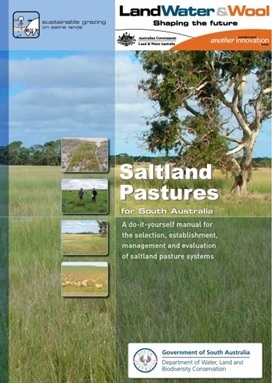
This Salt Land Pastures South Australia Manual provides information about saltland pastures and fodder shrubs, and is targeted at land managers, agronomists and extension workers. Information is based on trial and demonstration work carried out across South Australia, and much of it from within our region.
Saltland Pastures South Australia Manual
After looking through this manual land managers should be able to;
- Better understand the potential of saltland pastures and fodder shrubs
- Recognise suitable pasture plants for different classes of saltland
- Use tools for evaluating economic performance
- Better understanding of whether saltland productions systems are likely to be a success for them
- Characterise their saltland
- Appreciate other site factors that influence production and profitability
- Access tried and tested establishment and management techniques
- Appreciate the payoffs and pitfalls experienced by other farmers working with saltland
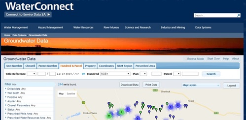
Water Connect - Groundwater Data Click here to find information on wells and groundwater in South Australia using this interactive online map.
https://www.waterconnect.sa.gov.au/Systems/GD/Pages/Default.aspx
Groundwater Data has information on over 240,000 registered wells across South Australia. It is easy to browse for wells using the Google Maps platform, including satellite imagery. Other search options include: by property, well construction permit number, and GPS co-ordinates.
Trends in groundwater and salinity levels are monitored over time using data from both private and government wells, assisting in groundwater resource management.
DEW Principal Hydrogeologist Steve Barnett has provided us with the following document explaining step by step how to successfully access groundwater data from this website.
How to access groundwater data from the Water Connect website
He has also provided step by step instructions for accessing up to date data for the Coomandook Landcare Observation Wells.
Accessing the Coomandook Landcare Observation Wells data
Water Salinity tolerance of different Plants and Livestock
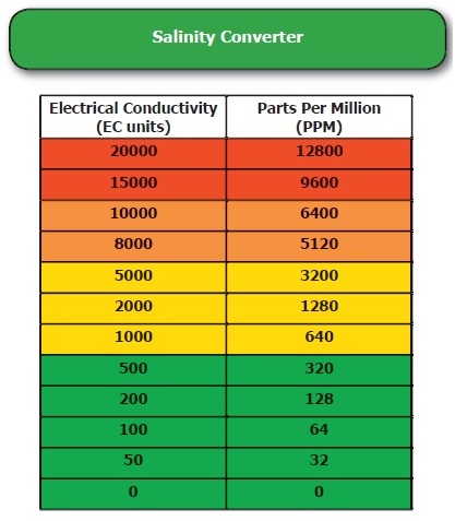
This brochure from the Victorian Dept of Sustainability and Environment, and Dept of Primary Industries provides easy to follow information on: salt tolerance of different plant species, salt tolerance of livestock, and a salinity conversion table.
http://www.gbcma.vic.gov.au/downloads/ssdp/GroundwaterGreen.pdf
You have nearly every other tool in your shed. Why not have a hand held EC Meter to measure salinity levels in your water and soil?